Hiking Mount Sabyinyo in Rwanda
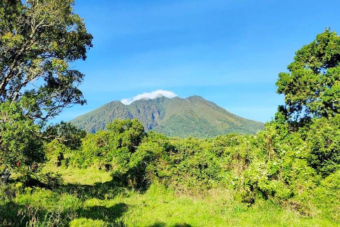
Mount Sabyinyo translates roughly to “old man’s teeth” in Kinyarwanda, a fitting name for a volcano whose jagged, eroded summit ridge looks nothing like the classic cone shape most people picture when they think “volcano.”
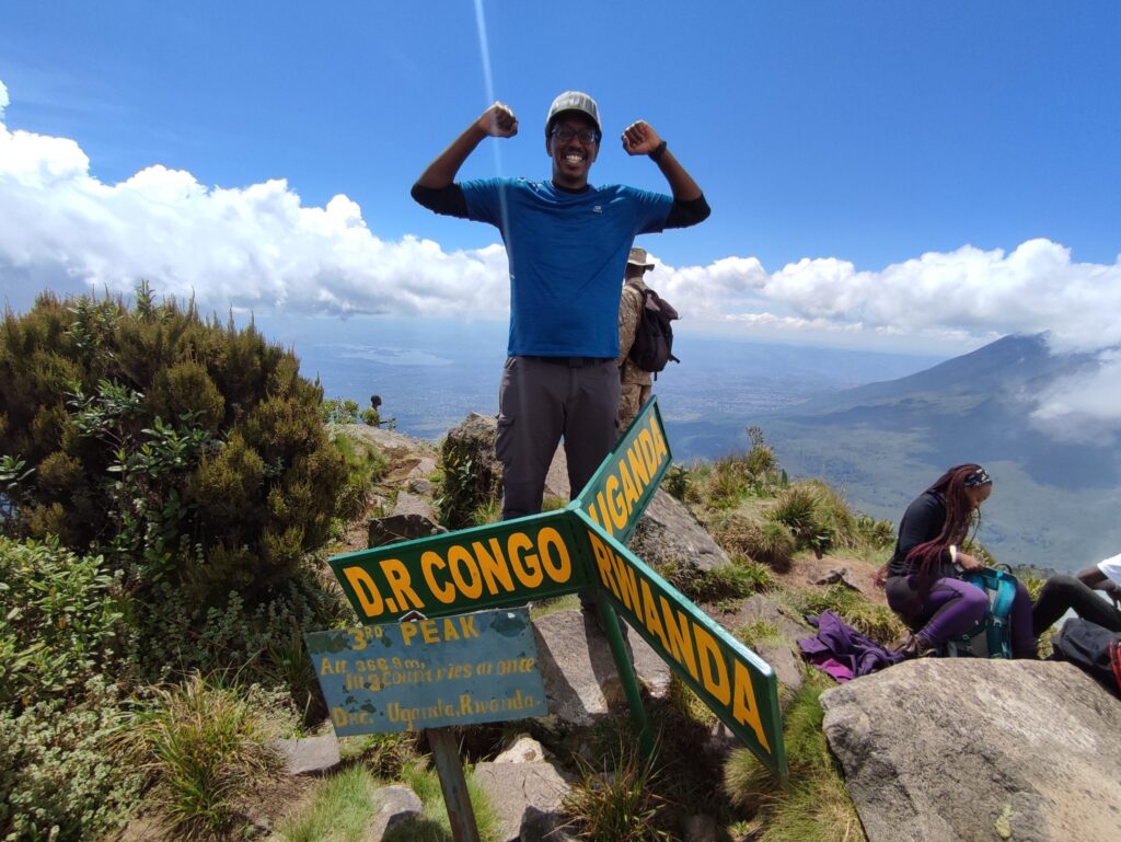
This is the most distinctive hike among Rwanda’s Virunga peaks, not because it is the tallest, Karisimbi and Muhabura both exceed it, but because its summit sits at the exact tripoint where Rwanda, Uganda, and DR Congo meet, and because reaching it involves climbing a series of exposed wooden and metal ladders bolted directly into a narrow volcanic ridge. Few day hikes anywhere in Africa combine this level of physical challenge with such a specific, novel geographic reward.
This guide covers exactly what the Sabyinyo hike involves, how difficult, what to expect from the tripoint summit experience, and how to decide whether it fits your Rwanda itinerary alongside gorilla trekking, so you can make an honest, informed decision rather than booking based on a striking photograph alone.
Should You Add Sabyinyo to Your Rwanda Trip?
Short answer: yes, if you have a appetite for a physically demanding, thrilling day hike and are comfortable with height and exposed ladder sections, since this is unlike anything else on a standard Rwanda gorilla trekking itinerary.
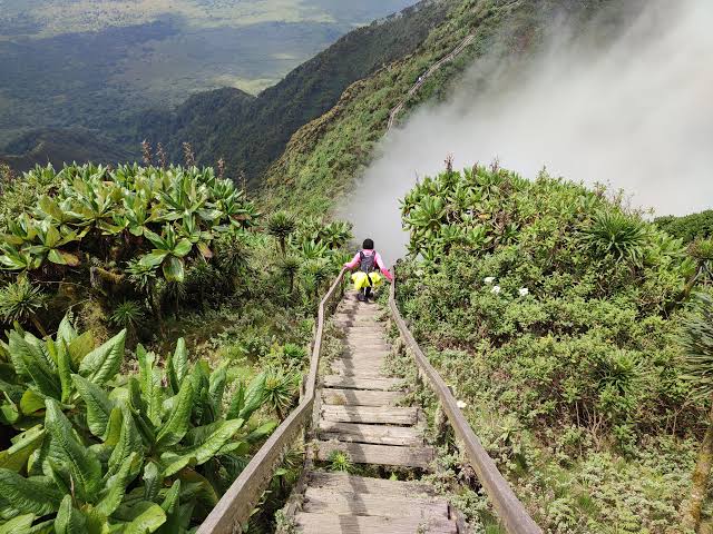
Sabyinyo is not for every traveller. The hike demands a full, strenuous day, and the final approach to the summit involves a series of ladders fixed to a narrow, exposed ridge with steep drops on either side.
If that description excites rather than concerns you, Sabyinyo delivers one of the most memorable single-day experiences available anywhere in the Virunga Massif. If heights or exposed scrambling make you uneasy, this is honestly not the hike to push through regardless, and there is no shame in choosing a gentler volcano instead.
Why Sabyinyo Stands Out Among Rwanda’s Volcanoes
Three features make Sabyinyo distinctive even within a range of already extraordinary volcanic peaks. First, its jagged, multi-peaked ridge formed through differential erosion of an old, extinct volcanic cone, creating a serrated skyline unlike Karisimbi or Muhabura’s more classically cone-shaped silhouettes.
Second, the summit ridge’s exact position at the intersection of three national borders means a single vantage point offers views across three countries simultaneously, a rare geographic novelty.
Third, the ladder sections near the top add a degree of technical, if non-technical-climbing, adventure that neither of Rwanda’s other two volcano hikes require to the same degree. Together these three features make Sabyinyo feel less like a scaled-down version of Karisimbi or Muhabura and more like an entirely different kind of mountain day out.
Where Sabyinyo Fits in the Virunga Range
| Peak | Height | Difficulty | Standout Feature |
| Mount Sabyinyo | 3,669 metres | Strenuous, with exposed ladder sections | Tripoint of Rwanda, Uganda, and DR Congo |
| Mount Gahinga | 3,474 metres | Moderate | Ends at a crater lake rather than a sharp peak |
| Mount Muhabura | 4,127 metres | Very strenuous | Crater lake at the summit, considerable elevation gain |
| Mount Karisimbi | 4,507 metres | Extreme, requires overnight camping | Rwanda’s highest peak, multi-day trek |
What the Sabyinyo Hike Actually Involves
The hike begins at Volcanoes National Park headquarters in Kinigi, where you meet your ranger guide and armed escort for a mandatory briefing before transferring to the trailhead. The route climbs steadily through cultivated farmland at the base, then into bamboo forest, before transitioning to increasingly sparse Afro-alpine vegetation as altitude increases.
The final section to the first of Sabyinyo’s three summit peaks involves a series of wooden and metal ladders bolted into the ridge, connecting increasingly narrow sections of exposed rock with drops on either side. Rangers pace the group deliberately through this transition, giving hikers time to adjust both physically and mentally before the ladder sections begin in earnest.
Practical implication: the ladder sections are the psychological and physical crux of the hike, and while they are secured and maintained, they demand a level of comfort with height and exposure that not every hiker will have, regardless of general fitness.
Most itineraries take hikers to the first peak, the highest and most accessible of Sabyinyo’s three summit points, where the tripoint boundary marker sits. Some experienced hikers with additional time and a willingness to negotiate further sections continue toward the second and third peaks, though this is less commonly attempted and depends on ranger guidance and weather conditions on the day. Attempting the second and third peaks adds meaningful time and further exposed scrambling, and rangers will only support this for groups that are clearly managing the first peak comfortably and have daylight to spare.
How Difficult Is Sabyinyo, Honestly
| Factor | What to Expect |
| Total duration | 7 to 8 hours round trip, including summit time |
| Elevation gain | Approximately 1,200 metres from the trailhead |
| Terrain | Farmland, bamboo forest, then increasingly steep, rocky ridge terrain |
| Technical difficulty | Ladder sections requiring comfort with height and some upper body effort |
| Fitness required | Good general fitness; this is more strenuous than gorilla trekking on an average day |
When to Hike Sabyinyo
| Season | Conditions | Recommendation |
| June to September, December to February (dry seasons) | Firmer trails, clearer summit visibility | Best window for both safety and views from the tripoint |
| March to May, October to November (wet seasons) | Muddier lower trails, increased risk on ladder sections | Still possible but more difficult and less rewarding for summit views |
What the Hike Costs
| Item | Approximate Cost | Notes |
| Sabyinyo hiking permit | $100 | Separate from the gorilla trekking permit |
| Porter fee | $15 to $20 | Strongly recommended given the terrain and pack weight for a full-day hike |
| Ranger and armed escort | Included in permit | Mandatory for all Virunga volcano hikes |
The Geology Behind the “Old Man’s Teeth”
Sabyinyo is one of the oldest volcanoes in the Virunga Massif, and unlike its younger, more symmetrical neighbours, it has had considerably more time for erosion to carve its once-continuous crater rim into the distinct, jagged peaks visible today.
This geological age is precisely what gives the mountain its name and its serrated silhouette, visible from a considerable distance across the Volcanoes National Park landscape and immediately distinguishable from Karisimbi or Muhabura’s more classic conical shape.
Understanding this history adds a layer of appreciation to the climb itself, since each of the three summit points you can see from the trail represents a separate remnant of what was once a single, much larger crater rim. Local guides often point out the visible layering in exposed rock faces along the route, a physical record of the eruptions that built the mountain long before erosion reshaped it into its current form.
What the Tripoint Summit Experience Actually Feels Like
Reaching the first peak and the tripoint boundary marker is a unusual moment even for well-travelled hikers. A small marker stone or beacon typically indicates the exact intersection point, and on a clear day, the view extends across Rwanda’s terraced hillsides, Uganda’s Mgahinga Gorilla National Park, and DR Congo’s Virunga National Park simultaneously, three entirely different national landscapes visible from one small patch of ground.
Guides typically allow a reasonable amount of time at the summit for photographs and rest before beginning the descent, which most hikers find nearly as demanding as the ascent given the same ladder sections in reverse. Many hikers describe the descent as requiring more concentration than the climb up, since fatigue has set in by that point and the ladder rungs demand the same careful attention regardless of direction of travel.
Comparing Sabyinyo From the Rwanda and Uganda Sides
| Approach | Country | Notes |
| Rwanda side (via Kinigi) | Rwanda | The standard, most commonly booked route, with well-established ranger support and permit systems |
| Uganda side (via Mgahinga Gorilla National Park) | Uganda | A separate hiking permit and trailhead, offering the same mountain from a different national park administration |
Sabyinyo can technically be climbed from either country, since the mountain itself straddles the border, but the two approaches are entirely separate bookings through separate park authorities, and most itineraries default to whichever country the rest of the traveller’s trip is based in.
Rwanda’s approach is generally considered the more established and frequently used route, with a more developed ranger support system and clearer trail markings given the volume of hikers it regularly receives compared with the Ugandan side.
Who Should Hike Sabyinyo
| Traveller Type | Fit | Reasoning |
| Adventure-seeking hikers with good fitness | Strong fit | The combination of physical demand and thrill from the ladder sections suits this profile precisely |
| Travellers uneasy with heights | Poor fit | The exposed ladder sections are a core, unavoidable part of the hike |
| First-time visitors to Rwanda with limited time | Moderate fit | Consider whether a full day for this hike competes with other priorities like gorilla trekking or Akagera |
| Photographers seeking unique vantage points | Strong fit | The tripoint summit view is difficult to replicate anywhere else in the region |
| Families with children | Generally not recommended | The physical demands and exposed sections make this unsuitable for most younger children |
What to Pack for Sabyinyo
- Sturdy, broken-in hiking boots. New or poorly fitted boots on a hike this demanding is a common and avoidable cause of blisters and discomfort.
- Gardening or work gloves. Useful for gripping ladder rungs and vegetation on both the ascent and descent.
- A hydration system or sufficient water bottles. The full-day duration and elevation gain make dehydration a risk without deliberate water intake throughout.
- A warm hat and light gloves for the summit. Wind chill at the higher elevations can make the tripoint noticeably colder than the trailhead conditions suggest.
- A daypack with a secure closure. Items shifting or falling out during the ladder sections are avoidable hazard.
Combining Sabyinyo With Gorilla Trekking
Most guests do not attempt Sabyinyo and a gorilla trek on consecutive days, since both are demanding, and stacking them without a rest day risks a poor experience on the second activity due to accumulated fatigue.
A more sensible structure places a rest or lower-intensity day, such as a Gorilla Guardians Village visit or golden monkey tracking, between the two more strenuous activities, giving your legs and general energy levels time to recover before the next full-effort day.
Frequently Asked Questions
Do I need climbing experience for the ladder sections?
No technical climbing skill is required, but comfort with height and exposed terrain is important. The ladders are fixed and maintained, but the surrounding terrain has real drops on either side.
Can I see all three countries from the summit?
Yes, clear weather permitting, the tripoint marker offers views across Rwanda, Uganda, and DR Congo simultaneously rare geographic experience.
Is Sabyinyo harder than a standard gorilla trek?
Generally yes, particularly due to the sustained elevation gain and the ladder sections, which introduce a height-exposure element gorilla trekking does not typically involve.
What is the minimum age for the Sabyinyo hike?
Requirements can vary, but this is generally considered an adult-level hike given its physical and height-exposure demands; confirm current age policy with the park authority when booking.
Is a permit required separately from the gorilla trekking permit?
Yes, Sabyinyo requires its own dedicated hiking permit, priced and booked separately from any gorilla trekking permit.
What happens if weather turns bad partway up the mountain?
Rangers monitor conditions closely and will turn a group back if lightning risk or extreme wind makes the ladder sections unsafe. This is a judgement call made on the day, and safety takes priority over reaching the summit regardless of how far the group has already climbed.
How does Sabyinyo compare to Mount Muhabura in difficulty?
Muhabura involves a greater overall elevation gain and longer sustained climbing effort, while Sabyinyo’s difficulty concentrates more specifically in the exposed ladder sections near the summit. Many experienced hikers find Sabyinyo more mentally demanding despite Muhabura’s greater physical distance and altitude.
Deciding If Sabyinyo Is Right for You
Sabyinyo rewards hikers who want something different from Rwanda’s primate-focused itineraries, a physically demanding, exposed ridge hike culminating in a rare three-country vantage point.
It is not the hike to choose if height or exposed scrambling makes you uneasy, and being honest with yourself about that beforehand leads to a far better outcome than discovering it partway up the ladders.